It’s an idea whose time has come and never quite gone.
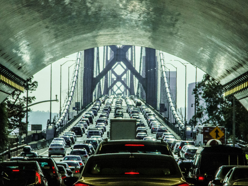
For three-quarters of a century, commuters have been struggling to get to San Francisco and the Peninsula in the morning and back to the more plentiful housing of the East Bay in the evening.
One solution—building another bridge across San Francisco Bay—has been on the boards since 1946. The span is often called the Southern Crossing because it would be located somewhere south of the Bay Bridge.
While Southern Crossing plans are still alive, experts believe it’s more likely the next crossing, or crossings, will be for BART and conventional rail, not cars and trucks.
The original Bay Bridge went into service on November 12, 1936, with traffic in both directions on the upper deck and rail service as well as cars on the lower half.
A few years later, the Bay Area’s population exploded during the World War II shipbuilding boom, and the bridge reached maximum capacity during peak hours.
The Bay Area in those days was the center of national defense on the West Coast. In 1946, soon after the war, a joint Army-Navy board recommended building a new bridge to promote economic growth and for military purposes.
Oakland wanted it close to the Bay Bridge, but San Francisco didn’t like the idea of more traffic pouring onto its downtown streets. Just five years after Pearl Harbor, the military made its choice.
“From a standpoint of national defense, if you built two bridges side to side they would be more vulnerable to a bomb than if you dispersed traffic and bridges, which was just common sense,” acting San Francisco Mayor Marvin Lewis told a congressional committee in 1953.
The new bridge became incorporated in an ambitious transformation of San Francisco Bay called the Reber plan. An actor, producer, and screenwriter named John Reber, best known for writing Mack Sennett silent comedies, came up with an idea that today sounds as ridiculous as those pie-in-the-face movies.
Reber wanted to build two dams to turn 85 percent of the Bay into two large freshwater lakes for recreational purposes and drinking water.
One of the dams would have been near the site of what’s now the Richmond-San Rafael Bridge. The other would have been south of the Bay Bridge, most likely from Fifth Street in Alameda to Army Street (now Cesar Chavez) in San Francisco. Cars and trains would travel on causeways on top of the dams, just as the already-built Hoover Dam allowed cars to cross from Nevada to Arizona.
The San Francisco Chronicle liked the idea in a 1946 editorial: “There are a great many difficulties to be surmounted, just as there were for the Bay and Golden Gate bridges, but they can be surmounted by application of the same kind of drive and technical know-how that brought the present great spans into being.”
In 1953, the state Legislature passed the Dolwig Act, allocating $7 million to plan a crossing designed to carry 75,000 vehicles a day on eight traffic lanes.
The plan had to go to Congress, because the only way to finance it was to use tolls from the Bay Bridge, and the 1931 act that authorized the bridge required that the bridge toll go to zero once the bonds to build it were paid off. In addition, the federal government had to be involved because the Army Corps of Engineers controlled bridge permits over navigable waterways.
A Congressional hearing in 1953 focused on amending federal law to allow bridge tolls to be collected for the purpose of building a new crossing.
Congressman William S. Mailliard, a Republican from San Francisco, said, “Just to briefly state the situation, we have these two metropolitan areas on both sides of San Francisco Bay joined by a bridge that has become very overcrowded and is unable to handle the traffic that wants to cross over there … Under the existing law the bridge will go toll free and I think it is quite clear that it will be almost impossible to build another bridge in the vicinity if you had one free bridge and had to have tolls on the other.”
But Oakland Mayor Clifford Rishell argued against it, saying Congress’ intent in authorizing the Bay Bridge in 1931 was to have it be free once it was paid off, and diverting money to a Southern Crossing that would only be used by an estimated 18 percent of the two-bridge traffic violated that promise.
Richmond City Manager Wayne Thompson called it “a shocking example of highway robbery” for the industrial workers of his city to have to continue to pay bridge tolls for a crossing they would never use. He warned the bill could lead to “a perpetual burden of tolls on the San Francisco-Oakland Bay Bridge.”
He was right. The toll in 1953 was 25 cents, or $2.42 in today’s money. The current peak-time toll is $7.
America’s foremost architect, Frank Lloyd Wright, proposed building a concrete structure called the “Butterfly Bridge,” resembling the flying insect. The beautiful bridge would have had six lanes of traffic on twin arches, as well as two pedestrian walkways (a forerunner of today’s bike lanes). Most daring was a “hanging garden” in the middle, where drivers could stop to enjoy the views.
A model was displayed in 1953, but the concept was never engineered or priced out. As an odd footnote, the model was displayed in the 1988 Bruce Willis movie “Die Hard.”
Delays boiled over into frustration. A Chronicle editorial from 1958 said: “More crossings over San Francisco Bay are needed. While this statement is generally unchallenged, it may be the only statement on the subject of transbay communications that can be made without provoking an outburst from some quarter of this balkanized, provincial, ill-organized, politically ill-led Bay Area community.”
About the same time, the Reber plan came to a dead end. The Army Corps of Engineers concluded that a division of the Bay into freshwater and saltwater areas could not be made to work.
Several changes staved off the need for a new bridge.
First, Key System electric commuter train service declined after World War II, a victim of commuter preference for cars, strikes by workers, and (some allege) a conspiracy by General Motors and other auto-related companies to buy up the shares of its parent company to kill it. Bay Bridge train service stopped in 1958, replaced by buses. That allowed the lower deck to be refitted entirely for cars. The new configuration with five lanes in each direction was opened in 1963.
Second, the San Mateo Bridge, built privately in 1929, was replaced. The old drawbridge was only two lanes and had to be raised and lowered an average of six times a day to allow ships to pass. The state-owned San Mateo-Hayward Bridge opened in 1967 and has been widened with completion of a second trestle in 2002.
Finally, construction of the BART Transbay Tube began in 1965. It opened in 1974, relieving traffic in downtown San Francisco and Oakland.
Still, the 1953 Legislative approval remained in force. In 1969, Bridge Authority Chief Engineer Mike Foley and Governor Ronald Reagan decided to ram it home. They pushed for construction to begin in 1972 on a twin-tower bridge from Alameda to San Francisco’s India Basin.
By then, though, the political climate had changed. San Francisco, Alameda and San Leandro all opposed the crossing.
The Save the Bay campaign was launched in 1961 by three area women. University of California, Berkeley geography professor Richard Walker said the movement changed the attitude toward the bay from a “place of production and circulation of goods and people… of no more aesthetic or spiritual import than today’s freeways” to a “vast scenic, recreational, and ecological open space.”
In 1972, Claire Dedrick of Menlo Park, co-founder and executive director of the Peninsula Conservation Center Foundation, went to Washington to speak against the bridge and other projects.
At the time, the state Division of Highways projected the Bay Area’s population would grow to an incredible 15 million by 2000, requiring massive high-rise development. “It’s hard to believe humanity can be that gosh-darn dumb, but you never know,” Dedrick said acidly.
The Legislature passed a bill banning construction unless there was a public vote. Reagan vetoed it. The Legislature put the measure on the ballot anyway.
The Redwood City Tribune editorialized: “The time has come to start blowing the whistle on road building projects which merely provide additional speedways leading into residential areas…growth has virtually stopped, and the possibility of major expansions into the area in the future are virtually impossible—unless we build more expressways and line them with apartments.”
Finally, on June 6, 1972, voters in six Bay Area counties had their say. The vote was overwhelming—939,053 to 283,111—to reject the bridge.
That put an end to the planning for 17 years. In 1989, then-state Senator Quentin Kopp, the chairman of the Senate Transportation Committee, revived the idea with a proposal for a bridge from San Leandro to San Bruno. San Mateo County environmentalists helped quash it, but the irascible San Franciscan did get something—Interstate 380, where the new bridge would have ended, was named in his honor.
In 2000, with traffic getting worse, Senator Dianne Feinstein, a former San Francisco mayor, got involved. “Work patterns have changed” since 1972, she said. “There wasn’t a Silicon Valley. There wasn’t a biotech industry. There wasn’t the volume coming in at the seaport and the airport.”
A study estimated the cost of a bridge at $8.2 billion. Besides the usual opposition from the Sierra Club and other environmentalists, the proposal languished because toll money had to be poured into cost overruns for the seismically required new eastern span of the Bay Bridge.
In 2017, Feinstein repeated the call along with Congressman Mark DeSaulnier, who represents Contra Costa County. They wrote a letter to the Metropolitan Transportation Commission, the planning, financing, and coordinating agency for the nine-county Bay Area.
“As your annual analysis of freeway congestion demonstrated earlier this Fall, the most congested freeway segments in the Bay Area for the second year in a row are the afternoon commutes northbound and eastbound on U.S. 101 and Interstate 80 from the I-280 interchange in San Francisco to the Bay Bridge’s Yerba Buena Island Tunnel. Moreover, the next most congested route is the westbound direction on I-80, through the Bay Bridge, to Fremont Street. A second crossing would alleviate this traffic through San Francisco and the East Bay, would better connect the entire Bay Area, and would provide significant benefits for toll payers,” the letter said.
Feinstein’s persistence is the biggest reason why the plan stays alive.
“She’ll bring it up and then it’ll go into hibernation,” said Adrian Brandt, a Redwood City transit advocate with Friends of Caltrain. “It’s an idea that won’t die.”
Brandt thinks the bridge does not make sense. “It will just increase the vehicle miles traveled and amount of driving. There’s a growing realization that isn’t our future. Any time you increase lanes it will increase driving.”
But DeSaulnier, who previously served on the MTC board and the transportation committees in both houses of the Legislature, said in an interview that the bridge is unfairly maligned as bad for the environment.
“If you look at corridor management, this is the busiest, most congested one.” That makes it hard for truckers, package deliveries, and other commercial purposes and causes wasted hours idling in traffic, burning carbon.
“My environmentalist friends argue you have to make it more like London to get into San Francisco,” by making it difficult and expensive to drive. “That misses the passthrough traffic to Silicon Valley, interstate trucks.”
DeSaulnier is a critic of MTC, saying that money from higher bridge tolls was wasted on $90 million in cost overruns for a new San Francisco headquarters for the agency and billions in overruns on the Bay Bridge rebuilding project.
He thinks a bridge is part of the solution, along with more BART, ferries, and conventional rail service. “From a systems management standpoint, we are very constricted, on the western side one of the highest densities in the country. How do we disperse that congestion?”
He points to the Seattle/Puget Sound area as a place with similar geographic constrictions that’s managing its most heavily used corridor better.
The Freight Action Strategy for Seattle-Tacoma (FAST) Corridor Partnership was started in 1998. It includes 25 high-priority transportation improvement projects between Everett and Tacoma. Thus far, 19 of the projects have been completed.
MTC, in conjunction with the Association of Bay Area Governments, recently studied the issue, including not just a bridge but also BART and rail connections. Its “Crossings” report, issued last November, says there are half a million crossings a day, 270,000 via the Bay Bridge, 230,000 by BART.
“While congestion relief on the Bay Bridge itself is unlikely even with new infrastructure, the only long-term solution to transit overcrowding in the corridor is construction of a new crossing,” the report said.
Seven concepts were studied, using three scenarios for growth by 2050.
1) A new Hayward-San Mateo Bridge with improved connections to Highway 101.
2) A Southern Crossing bridge (I-380 in San Bruno to I-238 and I-880 in San Lorenzo).
3) A second BART tube from Oakland to downtown San Francisco under Mission Street.
4) A second BART tube further south, with a tunnel under Third Street to Mission Bay, South Beach, and downtown San Francisco.
5) Cross-bay regional rail, with cross-bay service integrating Caltrain from San Jose and the Capitol Corridor from Sacramento at Salesforce Transit Center.
6) BART plus Southern Crossing bridge.
7) BART plus regional rail.
It concluded the three transit-only options (3, 4, and 5) were more cost-effective than the auto-only ones (1 and 2). “The conventional rail concept (#5) has a slightly higher benefit/cost ratio than the two BART-only options because of high housing and job growth forecasts for the conventional rail corridors,” including the Caltrain corridor on the Peninsula.
The study recommended moving forward with the three transit-only options as the first priority for further study and the multi-crossing options (6 and 7) as the second priority, while eliminating the auto-only options. A new bridge, which very possibly would be named after Feinstein, hangs on in option 6 by the slenderest of threads.
Retired longtime MTC Executive Director Steve Heminger said the most likely route would connect I-380 to I-238. However, the bay is at its widest at that point, making it more expensive. In addition, there just aren’t that many people who need to cross there.
“The evidence in the surveys we’ve done is most folks across the Bay Bridge are headed to a destination close to the other end of the Bay Bridge, not heading north from the East Bay, crossing, then heading south to the Peninsula. The answer we get back from our analysis is there is simply not enough demand between the Bay Bridge and the San Mateo Bridge to finance it. The numbers don’t come close to penciling out. There’s no way a bridge could pay for itself in that corridor.”
Heminger thinks the most likely alternative is a second BART crossing, financed mostly by a bridge tolls and property and sales taxes. BART is doing preliminary engineering now.
Currently, BART can run 23 trains an hour (213 cars) in each direction through the Transbay Tube at peak hours. Projects are in the works to increase train frequencies between San Francisco and Oakland by more than 30 percent, and overall capacity by approximately 45 percent. A major part of that is by replacing the 47-year-old train control system with one that can run trains closer together.
“With BART getting a new train control system, that will allow it to run trains a lot closer to each other, give us more capacity in the existing tube, but that will only last a certain amount of time,” Heminger said. “With job growth in San Francisco, we’ll need a new tube. Where that tube goes, there’s a considerable amount of debate.” The possibilities are to keep it in the existing corridor (under Mission Street) or serving South of Market and Mission Bay.
A BART tube could be made wide enough to encompass conventional rail as well, although it would be a challenge to pay for it, he said. In theory, conventional rail could allow Redwood City boarders a one-seat ride to Oakland and Sacramento.
An idea moving on a separate track is to restore the rail crossing near the Dumbarton Bridge, potentially connecting BART, ACE, and Capitol Corridor lines in the East Bay with Caltrain at the Redwood City train station.
The Dumbarton corridor had freight rail service from 1910 to 1982. The old trestle bridge was partly destroyed by arson fires starting in 1998 and an entirely new crossing would need to be constructed.
The idea of passenger service got a shot in the arm when Facebook took it up as a potential way to get employees and others to its headquarters on Willow Road near the west end of the Dumbarton and to its planned Willow Village mixed-use development.
The company formed a partnership with developer Plenary Group to examine the crossing, and SamTrans has joined the study.
Building a new bridge over the 1.3-mile span for either buses or trains would cost between $600 million and $1.8 billion, a study found.
No matter which alternatives are selected, the need for crossings will grow. Projections show Bay Area population increasing from 7.5 million in 2015 to 9.3 million by 2040. (Even that is far below the Division of Highways’ old projection of 15 million by 2000, a sign of how much attitudes toward high-density growth have changed).
“Given that this package would be measured in the BILLIONS of dollars, MTC almost certainly would play a role in working with the project sponsor (BART or other agency) in combining many different revenue sources (local, regional, state, federal). Alternatively, the preliminary engineering and design work could lead to a determination that the project costs would be greater than the benefits; which could put the whole idea back on the shelf,” said John Goodwin, an MTC spokesman.
“There’s a reason the last all-new transbay crossing was the BART Transbay Tube, almost 50 years ago,” Goodwin said. “These projects are extraordinarily hard to do.”
This story was originally published in the March print edition of Climate Magazine.

