If it seems hard to get around the Peninsula now, just imagine how long it would take to get around the county without its network of freeways and highways.
Still, those thoroughfares came at a cost.
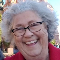
Karen Moresco Busch of Menlo Park experienced that firsthand as a high school student when her family home on Railroad Avenue in Colma came in the path of plans for Interstate 280 around 1961.
“It was a close neighborhood. All of a sudden they took it with eminent domain. In a way, it’s very sad, but Highway 280, we needed that.”
A glimpse of what was lost was provided by San Mateo County Historical Association President Mitch Postel in a January 28 Zoom presentation entitled “Get Out of the Way for the Highway,” featuring slides from a new photo collection.
Caltrans donated the collection, which otherwise would have been thrown away, to the San Mateo County History Museum in Redwood City. It includes 10 boxes of photos, maps, and property listings used to plan routes and acquire right-of-way.
“If you were to take a time machine and go back to 1940 on the Peninsula, you might not even know where you were,” Postel said. “But if you took same time machine and went to 1970, you’d know a lot. Roads, highways, schools, shopping centers materialized largely within that 30-year span.”
Roads to the Suburbs
The county mushroomed from 111,800 people in 1940 to 556,000 in 1970, even faster than California’s overall growth from 7 million to 20 million. Daly City alone grew sevenfold.
Postwar suburbanization occurred nationwide as people bought cars and moved out of crowded cities. The Bay Area’s expansion was particularly rapid.
“Our growth was largely people coming from other places all over the country. A lot of veterans had seen San Francisco during World War II and desired to come back. The airport was a tremendous source of jobs. While San Francisco was a source, our growth was based on people coming from all over the country and all over the world,” Postel said.
To accommodate them, better roads were needed.
Highway 101 had stoplights and no median strip and was considered one of the most dangerous in the country, earning the nickname “Bloody Bayshore.” The Division of Highways (forerunner of Caltrans) transformed it into a freeway in stages between 1947 and 1958, eliminating head-on crashes, according to the San Francisco Chronicle.
“Before that, you could cross Bayshore Highway at several points—Palo Alto and East Palo Alto were much more linked up,” Postel said.
A Freeway Divide
Photos show a thriving downtown East Palo Alto along the four-lane highway, including the art deco Auten’s Restaurant with a rocket-like tower at the corner of Bayshore and University Avenue.
Because Palo Alto banned alcohol sales due to land restrictions placed by Stanford University, restaurants and bars gravitated to the East Palo Alto side of San Francisquito Creek. Auten’s special dinner boasted a top sirloin steak, soup, salad, ice cream and coffee for $1.85.
It was demolished for freeway construction in the mid-1950s, along with a service station and a Spanish-style house on University appraised at $14,430, a high price in those days.
“East Palo Alto exists on both sides of the Bayshore, but after the freeway came through, the west side became known as Whiskey Gulch,” Postel said. “It really did destroy part of the sense of community of East Palo Alto.”
In his book “From Frontier to Suburb,” the late College of San Mateo historian Alan Hynding outlined the connection between the freeway and racism:
“…(T)he Bayshore Freeway isolated the town from other communities to the west. As business investors, apprehensive about the black population and the high incidence of poverty and crime, avoided the area, the employment problem worsened. Like Watts and other West Coast black enclaves, East Palo Alto had become a suburban ghetto of deteriorating neighborhoods, where unemployment ran at about 40 percent … Poverty, unemployment and a heavy turnover in the population left the town without any real economic or political base, and without much civic pride.”
Also taken was a portion of the Charles Weeks Poultry Colony, a chicken farm established in the 1920s as one of six such communes, known as runnymeads. The commune was mostly deserted by that time anyhow, Postel said.
In Redwood City, the effects of Bayshore widening were also notable, if less dire. The old highway had run along what is now Veterans Boulevard, south of the current path.
The Last Rodeo
The Peninsula Celebration Association had built a rodeo grounds for a two-day rodeo, part of the annual Fourth of July festivities. Photos show a grandstand at the side of the old highway, along with a racetrack, a hot dog booth, and a Wheel of Chance.
Construction of the freeway cut the grounds in two, Postel said. The rodeo ended in 1963. Proceeds from the sale of the land were placed in a fund to support the annual parade and fireworks, which continues to this day.
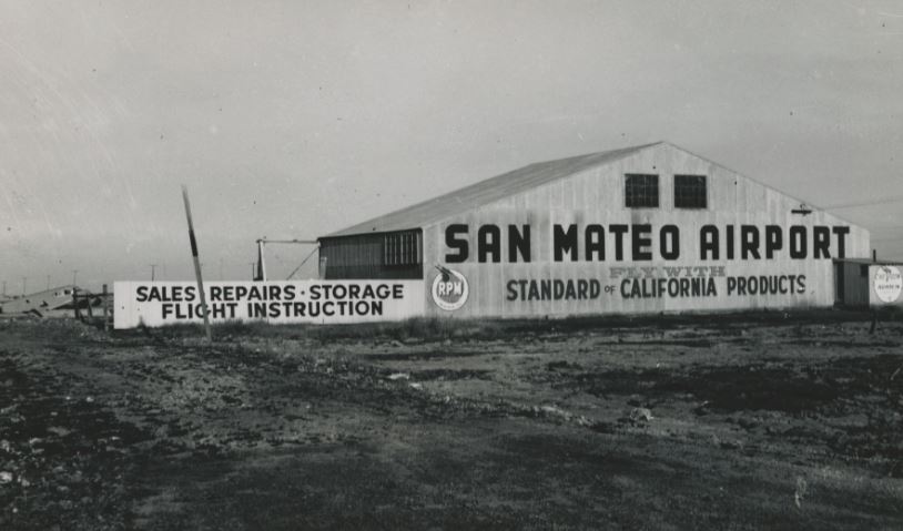
In San Mateo, widening of the Bayshore and the need for an interchange with Highway 92 spelled the end for Henry’s Garage, which included an auto wrecking business, service station, and tavern. Also demolished was the private San Mateo Airport, which had been in the area since at least 1947 but had never gotten title to its land.
Until the late 1960s, when community members blocked Interstate 380 from being extended to the coast, the Division of Highways simply appraised and took whatever was in the path.
“Early on, zero environmental reports were required. There was very little criticism of any of this development. By the time we got around to building 380, it became the focus of the early environmental movement and the thought of development down the coast was abhorrent to many people,” Postel said.
Interstate 380 was originally designed to connect the Bayshore to Highway 1, but only got as far as 280, less than two miles. Among the properties taken was a naval base across the street from the Tanforan racetrack. Some 81 homes were taken, among them one on Seventh Avenue in San Bruno for $10,760 in 1967.
Taken but Not Built
“Montara was maybe the saddest case. A dozen homes were taken for the freeway to bypass Devil’s Slide. These houses were taken and demolished despite the fact they were never needed for construction. Very few of the condemned homes were moved, most were demolished,” Postel said.
While the San Mateo coast never got the direct freeway connection that would have fueled suburbanization, it wasn’t immune from construction. In Half Moon Bay, Highway 1 (then State Route 56) ran through Main Street before being rerouted west. “That’s still the way it is. You can imagine traffic if it still ran through the center of town,” Postel said.
In Daly City and Colma, I-280 construction proceeded along the original San Francisco to San Jose rail line, which had been downgraded to a branch after the bayside cutoff route was completed in 1906. Parts of the line were repurposed as right-of-way for BART while 280 obliterated Railroad Avenue alongside it. Among the buildings taken was Colma’s community center.
Karen Busch, who lived on Railroad Avenue, remembered her vanished neighborhood as a friendly one full of working people, living up to the cemetery city’s tongue-in-cheek motto, “It’s great to be alive in Colma.”
Her house, rented for $50 a month, was one of the few that was moved rather than be destroyed, but her family departed for Watsonville.
She showed photos of the residents’ farewell party, a potluck featuring a cake with a railroad decoration.
“I don’t think I cried. It’s just what happened.”